

Google Maps Partners With Vagabond To Improve Vending Performance
 Google Maps for Work, a division of Google, Inc., has partnered with Vagabond to assist vending operators route trucks and inventory.
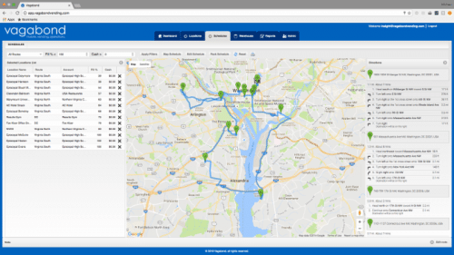
Google Maps’ knowledge of location addresses, fastest routes and access to the latest on what’s happening on the roads provides helpful insight for handling the complexities of fleet management.
Google Maps traveled throughout North and South America in 2016 learning about the vending industry through its collaboration with Vagabond. More recently, Google Maps has added Vagabond to its customers section. The section highlights the ways the vending industry’s technology providers take advantage of Google Maps APIs to pinpoint locations, schedule dynamically, plot live machine information into map formats, and route truck fleets.
Google Maps noted the Vagabond suite improves merchandising decisions, reducing time spent servicing machines and eliminating theft.
In a post detailing Vagabond’s use of the Google Maps Javascript API, Google explained how it helps provide vending operators real-time information on which machines and accounts need service as well as how the trucks should get to the machines.
Vagabond is featured alongside remote trash and waste tracking company, Enevo, and real-time pet monitoring service, Pod Trackers. All companies featured use live data in conjunction with Google Maps and IoT technology.
For more information visit vagabondvending.com
![]() Vending Technology News | More News | Vending Newsletter sign up | Questions? Contact us | email press release |
Vending Technology News | More News | Vending Newsletter sign up | Questions? Contact us | email press release |
Also see: Software Companies | Technology Companies | Micro Markets | Cashless Vending | Distributors | Classified Ads | Home |
VENDING YELLOW PAGES DIRECTORIES:
Call us at 1-800-956-8363 to POST YOUR COMPANY, or QUESTIONS?


